Free Gold Prospecting Maps for WA
"I've got the detector. I've got the Miner's Right. So where do I actually go?"
If that's you, good. You're asking the right question, and most people never ask it. They drive 700 kilometres, get out at the first bit of red dirt that looks "goldy", and swing a coil at it for three days. Then they go home with a bucket of rusty nails and a sore back.
Here's the bit most people don't believe: nearly everything you need to answer that question is free. The WA Government has spent decades mapping this state: every old mine, every rock type, millions of soil samples, millions of drill holes. It's all sitting online and costs nothing to look at.
The catch? It's spread across about a dozen websites that look like they were designed by a committee of geologists. I'm allowed to say that. I was one for 30 years.
So this page fixes that. 12 free maps, stacked into 5 layers, in the order I'd use them if I was starting from scratch tomorrow. For each one you get what it shows, where to click, and the one thing to look for.
The short answer
The best free gold prospecting maps in Western Australia come from the Department of Mines, Petroleum and Exploration (DMPE). GeoVIEW.WA shows geology, old tenement maps, soil geochemistry and drill holes. MINEDEX lists mines and abandoned mine sites. WAMEX holds company exploration reports. TENGRAPH Web shows who holds the ground today. Add Geoscience Australia's free AUSTopo maps and Google Earth Pro's historical imagery, and that's a complete research kit for $0.
The maps won't find gold for you. Used in the right order, though, they'll tell you where not to waste your weekend, and that's most of the battle.
Key takeaways
- Stack, don't browse. History → geology → chemistry → ground → tenure. Each layer narrows the one before it.
- Old workings are the start, not the target. The gold the old-timers found tells you which rocks to look for somewhere else.
- The best free clue is a soil anomaly nobody drilled. The geochem and WAMEX layers are where that lives.
- Tenure check goes last, and happens on the day. Ground changes hands every week. A screenshot from last month is worth nothing.
- WA's mines department changed its name on 1 July 2025 (it's DMPE now). Most tools still work, but lots of old links and guides are out of date.
The 5-layer free map stack
Every free map on this page answers one of five questions. Ask them in this order and each answer shrinks the area you're looking at, from "the whole Yilgarn" down to "that low rise with the ironstone on it, 400 metres east of the old shafts."
Why this order? Because the most common mistake I see is people starting at layer 5. They open TENGRAPH, find a gap in the tenements, and go detecting there because it's available. Available isn't the same as prospective. Plenty of ground is open precisely because nobody thinks there's anything in it.
Start with the gold, work out the geology, and only then worry about access.
Layer 1: Where gold's already turned up
Gold isn't spread evenly across WA. It clusters. Where the old-timers found it, there's usually more nearby, in the same rocks and along the same structures, just not in the exact spot they dug. So the first job is finding the clusters.
1MINEDEX: every mine, prospect and abandoned mine site
MINEDEX is DMPE's database of mines, mineral deposits and prospects. It covers everything from a working super pit to a single old shaft somebody sank in 1898. According to DMPE it's free to use with no login, and it includes an inventory of abandoned mine sites. For a detectorist, that last bit is gold. Well, it's the map to it.
You can search it directly at MINEDEX, but I find it far more useful as a layer in GeoVIEW.WA, where you can see the sites on the map alongside the geology.
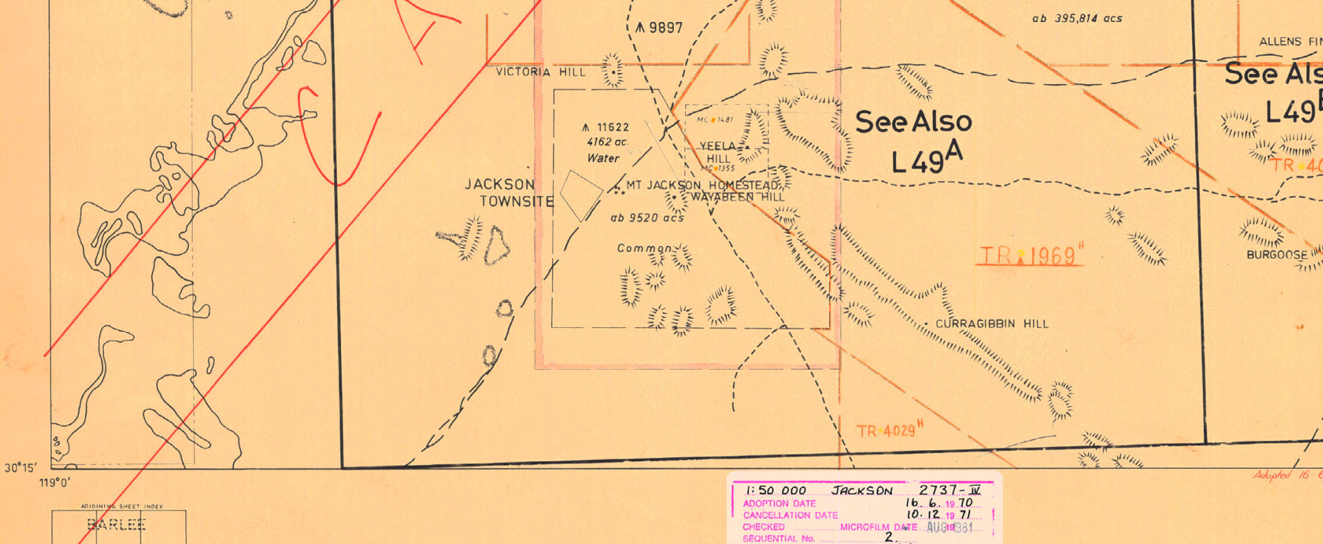
2Historical Mining Tenement Maps: the ground they pegged before computers
Before TENGRAPH existed, tenements were drawn by hand on paper plans. DMPE has scanned those and put them in GeoVIEW.WA as a layer. It's one of the most underused free resources in the state.
Why does it matter? Because people only pegged ground they thought was worth something. A cluster of old gold leases and alluvial claims on a 1930s plan tells you where the diggers were busy, and those areas often don't show up as "mines" in MINEDEX at all.
3Old goldfield plans: Trove and the State Library of WA
The National Library's Trove and the State Library of WA hold scanned goldfield plans from the 1890s onwards: lease plans, reef maps, geological sketches of mining centres. Search a centre name plus "goldfield" or "plan" and you'll find some beauties.
These are fantastic for history and for jogging your eye. They're also where most "free gold maps" websites stop. Here's my honest view: an old plan tells you where people dug, not where gold is left. Treat it as a pointer to an area, then move to layer 2 to work out why they were digging there.
And that's the lesson with every historical map: it's a clue, not an address.
Layer 2: Why it's there
This is the layer that separates people who find gold from people who find old workings. Once you know which rocks and which structures the old gold sits on, you can go looking for the same combination somewhere nobody's been.
4GeoVIEW.WA geology: the free map that does most of the work
GeoVIEW.WA is DMPE's free interactive map, and if you only learn one tool on this page, make it this one. Layers 1, 2 and 3 of the stack all live inside it: geology, MINEDEX, old tenement maps, soil geochemistry, drill holes and the outlines of company exploration reports.
Turn on the geology and the state lights up in colours. The ones you care about for gold are mostly the greenstone belts, the long strips of old volcanic and sedimentary rocks that run through the Yilgarn and Pilbara. Nearly all of WA's gold sits in or near them. Then look for the faults and shear zones, the lines where the rock has been broken and ground up. Those are the plumbing the gold travelled up.
If the map colours and codes do your head in (they do for most people at first), this is the video I'd watch first:

How to read geological maps for gold prospecting in WA (19 min)
5GSWA geological map sheets and explanatory notes: the old paper maps
Before GeoVIEW, the Geological Survey of WA published printed map sheets at 1:250,000 and 1:100,000 scale, each with a booklet of "explanatory notes" written by the geologist who mapped it. DMPE's eBookshop lists nearly 5,000 geological products, and most are free PDF downloads.
Why bother when GeoVIEW exists? Two reasons. First, the old sheets often show detail that didn't survive into the digital compilations. Things like alluvial and colluvial deposits, laterite, old workings and little notes in the margins. Second, the explanatory notes are written in sentences. The geologist tells you where the gold was, what it was in, and sometimes what they thought was worth another look.
I made a whole video on why these old paper maps still beat the online versions for some jobs: How 1970s paper maps reveal alluvial gold you can't see online.
Layer 3: What the explorers found
This is my favourite layer, and it's the one almost nobody else writing about free maps even mentions.
Every exploration company that holds ground in WA has to report what it did. So when a company walks away, its work stays behind: soil samples, drill holes, maps, the lot. After the confidentiality period (I believe its 7 years), you and I get to read it for free. That's millions of dollars of exploration work, and most prospectors have never opened it.
6Surface geochemistry: millions of soil samples, free
DMPE's surface geochemistry database holds over 6 million surface samples, according to DMPE's systems list. A geochemical anomaly is just a patch of ground where the soil chemistry says "something's going on down there." When you colour the samples by gold value, the anomalies jump straight out.
Watch the units. Soil gold is usually reported in ppb (parts per billion), not grams per tonne. 1,000 ppb = 1 g/t. A soil result of 50 ppb isn't "50 grams". It's a whisper, but in the right place a whisper is worth following.
7Company mineral drillhole database: where they drilled (and where they didn't)
The drillhole layer shows over 2.4 million historic drill holes, per DMPE. On its own it's just a lot of dots. Put it on top of the soil geochemistry and it tells a story.
8WAMEX: the company reports behind the dots
WAMEX is the library of company exploration reports. Found an interesting anomaly in GeoVIEW? Click the report outline over it, grab the report number, and download the whole thing. Maps, sample results, drill logs, and the geologist's own conclusions.
The part I always read first is the recommendations at the end. That's where the company geologist writes "further work is warranted on X" and then, often, nobody ever did it.

Finding company exploration reports in GeoVIEW (5 min)
Layer 4: What it looks like on the ground
You've got a target on a screen. Now you need to know what it looks like standing on it, and how you're going to get there without ripping a sidewall out.
9Aerial imagery: Google Earth Pro and Landgate Locate
Google Earth Pro (the free desktop version) has one feature every prospector should know: the historical imagery slider, the little clock icon. Step back through the years and you'll often see old scrapes, dryblowing heaps, tracks and shafts that have since been bulldozed or grown over.
Landgate's Locate is free for personal, non-commercial use and lets you overlay Landgate's aerial photography, roads and historical maps.

Find lost and forgotten gold mines using aerial imagery (11 min)
10AUSTopo 1:250,000 topographic maps: free, and they work with no reception
This one's new-ish. In March 2026 Geoscience Australia announced that its AUSTopo 1:250,000 topographic maps now cover all of Australia, current and previous editions, all free to download from their map dashboard.
Out past the last bar of reception, a PDF on your phone or a printed sheet in the glovebox is worth more than every web map on this page. Tracks, bores, fence lines, creeks, homesteads: it's all on there.
Layer 5: Are you allowed to be there?
Here's where it gets serious. Everything above tells you where you'd like to go. This layer tells you whether you can. Get this wrong and you're not just wasting a weekend. You can lose your gear and your finds, and cop a very significant fine, possibly even jail time
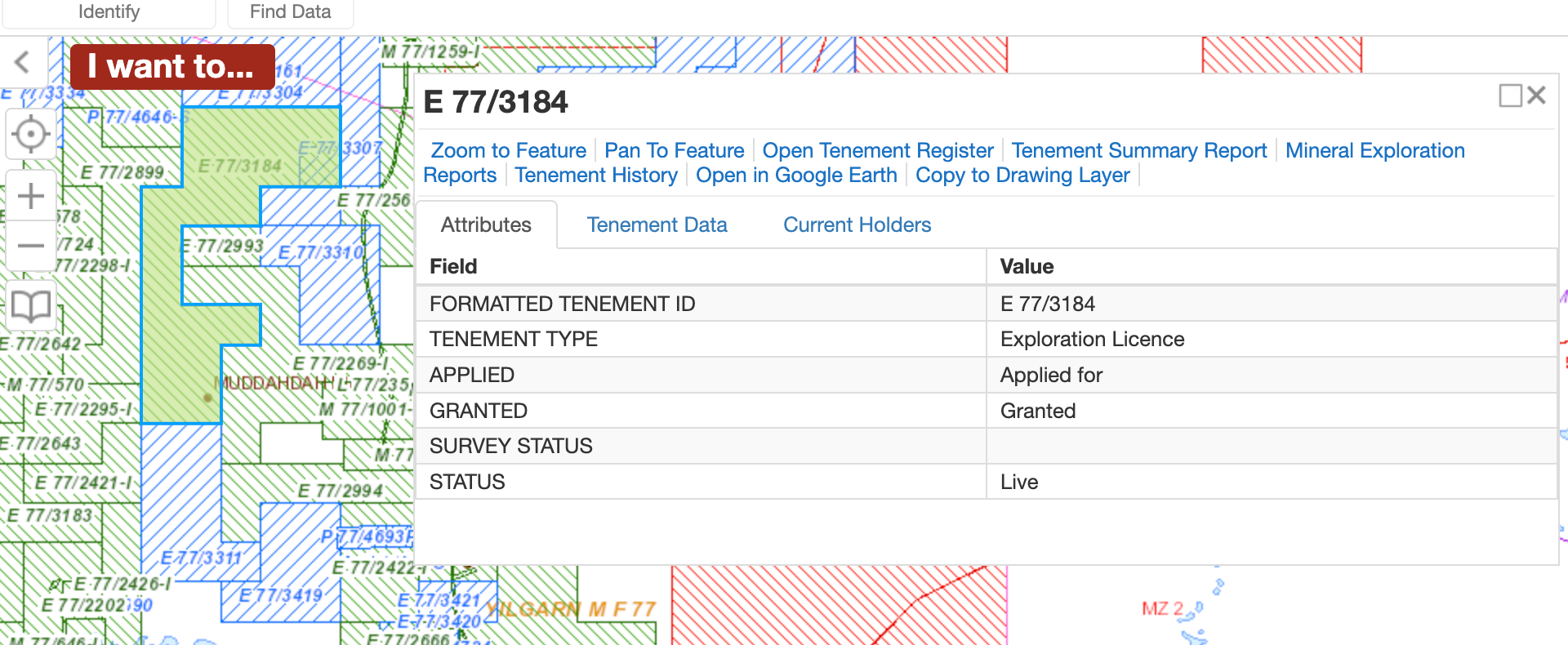
11TENGRAPH Web: who holds the ground today
TENGRAPH Web is DMPE's tenure map. It shows every live and pending mining tenement: exploration licences, prospecting licences, mining leases, the lot. DMPE's own TENGRAPH Web page was last updated in June 2026. Click a tenement and you get the holder, the type and the status.
If you want to see what's been freshly applied for or surrendered, DMPE's Mining Notices page lists new applications and surrenders, also free.
• Open Crown land, no tenement: you can prospect with a Miner's Right, subject to the restrictions below.
• Exploration licence: you need a Section 40E permit or written permission from the holder.
• Prospecting licence or mining lease: you need the holder's written permission.
• Pending tenement (ground someone's applied for but doesn't hold yet):
• National parks, nature reserves and other reserves: generally off limits.
Even on open Crown land, a Miner's Right doesn't let you go everywhere. DMPE's Miner's Right guidance says you need the occupier's consent to prospect within 100 metres of crops, yards, gardens, buildings and cemeteries, and on pastoral leases within 400 metres of water works, dams and bores.
12ACHIS: Aboriginal cultural heritage places
The Aboriginal Cultural Heritage Inquiry System maps registered Aboriginal heritage places across WA. A lot of goldfields country is on or near them. Check your target area, and if a place is marked there, leave it alone. It's the law, and it's the right thing to do.
The rules change. What's on this page is right as far as I know today, but before you head out, check the current requirements with DMPE and the Miner's Right page. Five minutes of checking beats a fine every single time. And just because a free map shows gold somewhere doesn't mean the ground is available.
All 12 free maps compared
Bookmark this table. It's the whole page on one screen.
| # | Free map | Layer | What it tells you | Login? | Offline? |
|---|---|---|---|---|---|
| 1 | MINEDEX | History | Mines, prospects, abandoned mine sites | No | Export |
| 2 | Historical tenement maps | History | Where people pegged ground before computers | No | No |
| 3 | Trove / SLWA goldfield plans | History | Old reefs, shafts, alluvial diggings | No | Download some |
| 4 | GeoVIEW.WA geology | Geology | Greenstone belts, faults, shears | Yes | No |
| 5 | GSWA map sheets + notes | Geology | Detailed geology plus the geologist's written notes | No | Yes (PDF) |
| 6 | Surface geochemistry | Chemistry | Soil gold anomalies | No | No |
| 7 | Drillhole database | Chemistry | Where companies drilled, and where they didn't | No | No |
| 8 | WAMEX | Chemistry | The full company reports and recommendations | No | Yes (PDF) |
| 9 | Google Earth Pro / Locate | Ground | Old scrapes, heaps, tracks, vegetation lines | No | Partial cache |
| 10 | AUSTopo 1:250k | Ground | Tracks, bores, fences, creeks | No | Yes (PDF) |
| 11 | TENGRAPH Web | Tenure | Live and pending tenements today | No | Yes, check on the day |
| 12 | ACHIS | Tenure | Registered Aboriginal heritage places | No | No |
The 45-minute desk workflow: putting it all together
Here's how the stack works on a real evening at the kitchen table. Pick one goldfield you can actually get to, not the whole state, and run through this.
- Find the gold (10 minutes). Open GeoVIEW.WA. Turn on MINEDEX mines and the historical tenement maps. Zoom into your goldfield and note where the small gold workings cluster. Drop a pin on each cluster.
- Find the reason (10 minutes). Turn on the geology. What rock are those workings sitting on? Is there a fault or shear running through them? Now follow that same rock and that same structure away from the workings, especially round the bends. Mark two or three spots with no workings at all.
- Find the leftovers (10 minutes). Turn on surface geochemistry and drillholes. Do any of your marked spots have a soil anomaly? Any drill holes on it? An anomaly with no drilling goes to the top of the list. Click the report outline and download the WAMEX report for later.
- Look at the ground (10 minutes). Open your top two spots in Google Earth Pro. Wind the historical imagery back. Look for old scrapes, heaps, tracks in, and the vegetation line. Download the AUSTopo sheet for the area.
- Check access (5 minutes, and again on the day). TENGRAPH Web for tenure, ACHIS for heritage. If it's under an exploration licence, sort a 40E permit or holder permission. If it's a mining lease, you need the holder's written permission, or you move on.
Done properly, you walk out of that evening with two or three targets you understand. You know why they might hold gold, and you're not just standing where someone else once stood.
Tell me in the comments on the YouTube channel: which of these five steps do you already do, and which one have you been skipping? I'd put money on step 3. Almost everybody skips step 3.

Simple guide to finding gold prospecting locations in WA (14 min)
WA's goldfields at a glance
WA was carved up into goldfields during the rushes of the 1890s, and those names are still stamped all over the maps: on old plans, in WAMEX reports, and in TENGRAPH's mineral field boundaries. If you know which goldfield you're in, every free map above gets easier to search.
| Goldfield | Region | Some well-known centres |
|---|---|---|
| East Coolgardie | Eastern Goldfields | Kalgoorlie, Boulder, Bulong |
| Coolgardie | Eastern Goldfields | Coolgardie, Kunanalling |
| North East Coolgardie | Eastern Goldfields | Kanowna, Kurnalpi |
| Broad Arrow | Eastern Goldfields | Broad Arrow, Ora Banda |
| North Coolgardie | Eastern Goldfields | Menzies, Ularring, Yerilla |
| Mount Margaret | North-Eastern Goldfields | Leonora, Laverton, Mount Morgans |
| Dundas | South-Eastern Goldfields | Norseman |
| Yilgarn | Southern Cross region | Southern Cross, Marvel Loch |
| Phillips River | South coast | Ravensthorpe |
| Murchison | Murchison | Cue, Day Dawn, Mount Magnet, Meekatharra |
| East Murchison | Murchison | Wiluna, Lawlers, Sandstone (Black Range) |
| Yalgoo | Murchison | Yalgoo, Paynes Find |
| Peak Hill | Northern Murchison | Peak Hill |
| Pilbara | Pilbara | Marble Bar, Nullagine |
| West Pilbara | Pilbara | Roebourne district |
| Ashburton | Pilbara / Gascoyne | Upper Ashburton district |
| Kimberley | Kimberley | Halls Creek |
For the Murchison centres in more depth (Cue, Day Dawn, Mount Magnet and Yalgoo), there's a stack of free material in the GSWA explanatory notes for those map sheets. See map #5.
5 mistakes people make with free prospecting maps
1. Starting with tenure instead of gold
Covered this up top, but it's the big one. A gap in TENGRAPH isn't a target. It's just a gap. Find the geology first.
2. Detecting the old workings instead of learning from them
The ground right around a shaft has usually been flogged to death by every detector since the first Minelab. The old workings are the answer to "which rocks carry gold here?" Go and find those rocks somewhere quieter.
3. Trusting old production figures
Historical production numbers can be rubbery, to put it politely. Some were talked up to sell shares. Others were never recorded because the gold went straight into someone's pocket. Use them as "there was gold here", not "there was exactly this much." I did a quick video on this: Don't trust the old-timers' gold mine values.
4. Reading ppb as grams
Soil results in parts per billion look big. They're not. 1,000 ppb is 1 gram per tonne. What matters in soil geochem is the pattern, a cluster of values well above the local background, not any single number.
5. Using a screenshot from last month
Tenure changes constantly. Ground that was open when you planned the trip can be pegged by the time you arrive. Check TENGRAPH again the morning you head out, or the night before from the last town with reception.
Free vs paid: an honest take
Full disclosure: I run GoldProspectingWA, which is a paid tool. So take this with the appropriate grain of salt, but here's my honest view.
The free maps above hold most of the raw data. If you've got more time than money and you enjoy the research, you can absolutely do this for nothing. Plenty of people do. Nobody should tell you otherwise.
What paid tools sell you isn't secret data. It's time. The free layers live in different places, run at different speeds and don't talk to each other. You're switching between GeoVIEW, TENGRAPH and WAMEX, and doing the stacking in your head. A paid tool puts the layers on one map, keeps the tenure current and, in some cases, works out in the field. On our side, GoldProspectingWA carries tenements updated daily, plus soil samples and drilling locations on the same map.
So here's the question I'd ask yourself. If you get out bush three or four times a year and each trip costs you a few hundred bucks in fuel and food, how many research hours is it worth saving to make sure every trip is on the best ground you can find? For some people that's zero. For others it's a no-brainer. Only pay if it makes sense for you.
What's changed in 2025–26 (and why a lot of guides are out of date)
- New department name. The Department of Mines, Petroleum and Exploration (DMPE) was formed on 1 July 2025. If a guide tells you to go to "DMIRS" or "DEMIRS", it's out of date, and some old links now redirect or break.
- The core tools are still running. GeoVIEW.WA, TENGRAPH Web, MINEDEX, WAMEX, the eBookshop and DASC are all on DMPE's current online systems list, and all are listed as free.
- Free national topo maps are complete. Geoscience Australia finished its AUSTopo 1:250,000 national series in 2026, free to download.
- Mineral Titles Online needs a login; TENGRAPH Web and Mining Notices don't. For checking tenure as a prospector, TENGRAPH is the one you want.
I re-check every link and status on this page regularly. Spot something that's changed? Let me know through the contact page and I'll fix it.
Pre-trip free map checklist
Screenshot this, or print it and stick it in the glovebox.
- Two or three targets marked, each with a reason (rock + structure + chemistry)
- WAMEX report for the area downloaded and the recommendations read
- GSWA explanatory notes for the map sheet downloaded
- AUSTopo 1:250k sheet saved to phone and printed
- Google Earth imagery of targets saved offline or screenshotted
- TENGRAPH checked for tenure, and checked again the day before
- ACHIS checked for heritage places
- Miner's Right current, plus 40E permit or written holder permission if needed
- Someone at home knows exactly where you're going and when you'll be back
Frequently asked questions
Where can I get free gold prospecting maps for Western Australia?
The best free gold prospecting maps for WA come from the Department of Mines, Petroleum and Exploration (DMPE). GeoVIEW.WA shows geology, historical tenement maps, surface geochemistry and drillholes; MINEDEX lists mines and abandoned mine sites; WAMEX holds company exploration reports; and TENGRAPH Web shows current tenure. All of these are free to use. Add Geoscience Australia's free AUSTopo topographic maps and Google Earth Pro's historical imagery, and you have a complete free research kit.
Is GeoVIEW.WA free to use?
Yes. GeoVIEW.WA is a free, web-based mapping system run by the WA Department of Mines, Petroleum and Exploration. It combines geology, mines, surface geochemistry, drillholes, historical tenement maps and exploration report locations in one map.
What is the difference between GeoVIEW.WA and TENGRAPH Web?
GeoVIEW.WA is for finding prospective ground: geology, geochemistry, drilling and old mines. TENGRAPH Web is for checking tenure: which mining tenements are live, pending or dead on a given day. Use GeoVIEW to decide where you would like to go, and TENGRAPH to check whether you are allowed to go there.
Do I need a Miner's Right to use free prospecting maps?
No. Anyone can view the maps. You need a Miner's Right to actually prospect or metal detect on Crown land in Western Australia, and on ground covered by an exploration licence you also need a Section 40E permit or the holder's permission. Rules change, so check current requirements with DMPE before you go.
If a free map shows old gold workings, can I detect there?
Not automatically. Old workings shown on historical maps are often covered by current mining tenements, pastoral leases, reserves or heritage places. Always check TENGRAPH Web for current tenure and ACHIS for Aboriginal heritage places on the day you plan to go.
Are there free prospecting maps I can use offline in WA?
Yes. Geoscience Australia's AUSTopo 1:250,000 topographic maps are free PDF downloads that work offline, and most Geological Survey of WA map sheets and explanatory notes are free PDFs from the DMPE eBookshop. Download them at home before you lose phone reception.
How accurate are old goldfield maps?
Old goldfield plans are good at showing where people dug, and often poor at exact positions and production figures. Treat them as a pointer to an area, then confirm the position on modern aerial imagery before you drive out.
What happened to DMIRS and DEMIRS?
Mining administration in WA moved to the new Department of Mines, Petroleum and Exploration (DMPE), formed on 1 July 2025. Most of the old online systems (GeoVIEW.WA, TENGRAPH Web, MINEDEX, WAMEX) are still running, but many older DMIRS and DEMIRS links now redirect, so update your bookmarks.
Are paid gold prospecting map apps worth it?
The free government maps contain most of the raw data. Paid tools save time by combining the layers, keeping tenure current and working in the field. If you have more time than money, the free stack is enough. If you only get a few trips a year, paying to save research hours can make sense.
Want the stack on one map?
Everything on this page works for free, and I'd encourage you to learn it. When you'd rather spend your evenings choosing targets than juggling five websites, GoldProspectingWA puts tenements, soil geochemistry, drilling and geology on one map, with tenure updated daily. There's a 30-day money-back guarantee if it's not for you.
See how GoldProspectingWA works →